Have a project in mind?
info@geotopo.gr
Interested working in together?
+30 210 8016363

Have a project in mind?
info@geotopo.gr
Interested working in together?
+30 210 8016363
Aerial photographs give a fully detailed picture of the geographic information at the time they were taken. A photo interpreter examines the aerial photographs thoroughly, usually consulting other maps and data (concerning the geographic information)
This interpretation is based on structures as well as the natural features shown in the aerial photographs and can either be a simple interpretation or a fully detailed, complex report concerning the geographic information as well as the subsoil. The result depends on the interpreter and his level of ability, on the type of the ground and the quality of the photographs.
Our office has extensive experience in the field of photointerpretation. Our photointerpretation studies are conducted by specialized survey engineers with expertise in photointerpretation, remote sensing, and photogrammetry, using PHOTOMOD Lite software, which is a comprehensive digital photogrammetric workstation.
Our Photogrammetry & Aerial Photographic and Satellite interpretation service includes a technical report in which the interpreter describes in full detail the methods used, and any errors, along with an analytical description of every aerial photograph.
Aerial Surveys along with the original aerial photographs, describing the interpretation’s results are also included.
The survey can be either an aerial photographic & satellite image interpretation, or a photogrammetric analysis.
A 3d presentation is provided, if required.
Aerial photographs are used as very strong evidence to support a claim. Not only because they are public documents, but also because they provide unquestionable data. Due to the use of specialised technology and the fact they specify the time taken, aerial photographs are the best way to reflect reality. They can also be used as proof of the actual time taken or even combined with other aerial photographs for more detailed results. Aerial photographic and satellite image interpretation & photogrammetric analysis may be used:
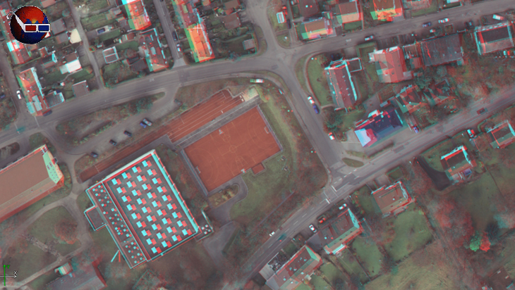
If you have red and blue filter glasses, you can view the below image stereoscopically.
Adding {{itemName}} to cart
Added {{itemName}} to cart